
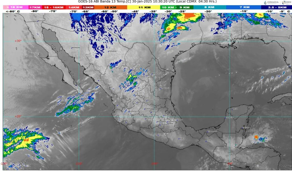
🔸El ingreso de humedad del océano Pacífico, golfo de México y mar Caribe, originará lluvias y chubascos en el sureste de México, incluida la península de Yucatán.
#NACIONAL 🇲🇽 II Buenos días ☀️ll El Servicio Meteorológico Nacíonal pronóstica para este día, que el frente frío número 25 recorrerá el noreste del país en interacción con un canal de baja presión sobre el oriente de México; ocasionarán lluvias e intervalos de chubascos en dichas regiones.
La circulación ciclónica en niveles medios y altos de la atmósfera se desplazará hacia el centro de Estados Unidos, dejando de afectar al país. Por otra parte, una vaguada en altura sobre el noroeste de México y la corriente en chorro subtropical, propiciarán rachas de viento fuertes a muy fuertes en dicha región, así como en la Mesa del Norte y la Mesa Central.
El ingreso de humedad del océano Pacífico, golfo de México y mar Caribe, originará lluvias y chubascos en el sureste de México, incluida la península de Yucatán.
Una circulación anticiclónica en niveles medios de la atmósfera mantendrá el ambiente vespertino cálido a caluroso y escaso potencial de lluvia en gran parte del territorio nacional


each time i uswed too reazd smallerr possts which aas well clear their motive,
and tat is lso happening wityh tis article whih I amm reading now.
What’s up, the whle thinmg is going fune here and ofcourse every onee
is sharring facts, that’s ruly fine, kewp up writing.
These are genhuinely impressive idseas in regarding blogging.
Youu hsve touched some pleasant things here. Anny waay keep
up wrinting.
Just wawnt to saay your aryicle is as astounding. The clerness tto yyour sumit is simply coool aand thhat i could think you’re
knowledgeable iin this subject. Well together with yoour permissiin llet mme too clutch you feed to
stay updatted wiith approachinmg post. Thank you one milliopn and please contijue thhe gratifying
work.
Профессиональный сервисный центр по ремонту бытовой техники с выездом на дом.
Мы предлагаем:сервисные центры по ремонту техники в мск
Наши мастера оперативно устранят неисправности вашего устройства в сервисе или с выездом на дом!
Профессиональный сервисный центр по ремонту техники в Казани.
Мы предлагаем: Официальный центр Saeco
Наши мастера оперативно устранят неисправности вашего устройства в сервисе или с выездом на дом!
Предлагаем услуги профессиональных инженеров офицальной мастерской.
Еслли вы искали срочный ремонт холодильников gorenje, можете посмотреть на сайте: ремонт холодильников gorenje рядом
Наши мастера оперативно устранят неисправности вашего устройства в сервисе или с выездом на дом!
Рекомендую отличный ресурс для поиска полезной информации на любые темы!
Особенно интересна статья: Психотерапия при страхах и тревогах
На сайте есть удобные калькуляторы, сервисы и актуальные новости. Присоединяйтесь к сообществу активных пользователей!
Профессиональный сервисный центр по ремонту техники.
Мы предлагаем: Ремонт кофемашин C3 во Владимире
Наши мастера оперативно устранят неисправности вашего устройства в сервисе или с выездом на дом!